|
|
|||||||||||||||||
| Point ID: 7190 | Downloads | Plots | Site Data | Code: 12153 |
|
|
|||||||||||||||||
| Download | |
|---|---|
| Site Descriptor Information | Site Time Series Data |
| Link to all available data | |
| View: | Time Series | All |
| Units: | mm |
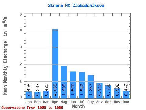
| Statistic | Jan | Feb | Mar | Apr | May | Jun | Jul | Aug | Sep | Oct | Nov | Dec | Annual |
|---|---|---|---|---|---|---|---|---|---|---|---|---|---|
| Mean | 0.41 | 0.39 | 0.43 | 4.07 | 1.91 | 1.57 | 1.54 | 1.37 | 0.91 | 0.76 | 0.58 | 0.44 | 1.31 |
| Standard Deviation | 0.28 | 0.33 | 0.31 | 2.14 | 1.44 | 1.26 | 1.32 | 1.55 | 0.91 | 0.62 | 0.40 | 0.30 | 0.69 |
| Min | 0.04 | 0.03 | 0.03 | 1.01 | 0.34 | 0.27 | 0.18 | 0.18 | 0.17 | 0.20 | 0.10 | 0.09 | 0.47 |
| Max | 1.03 | 1.35 | 1.38 | 8.95 | 5.43 | 3.91 | 3.86 | 6.34 | 4.11 | 2.91 | 1.68 | 1.19 | 2.88 |
| Coefficient of Variation | 0.70 | 0.86 | 0.73 | 0.53 | 0.75 | 0.80 | 0.85 | 1.13 | 0.99 | 0.82 | 0.69 | 0.69 | 0.53 |
 Return to R-Arctic Net Home Page