|
|
|||||||||||||||||
| Point ID: 7190 | Downloads | Plots | Site Data | Code: 12153 |
|
|
|||||||||||||||||
| Download | |
|---|---|
| Site Descriptor Information | Site Time Series Data |
| Link to all available data | |
| View: | Time Series | All |
| Units: | m3/s |
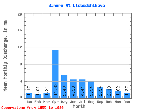
| Statistic | Jan | Feb | Mar | Apr | May | Jun | Jul | Aug | Sep | Oct | Nov | Dec | Annual |
|---|---|---|---|---|---|---|---|---|---|---|---|---|---|
| Mean | 1.17 | 1.01 | 1.24 | 11.33 | 5.49 | 4.38 | 4.44 | 3.94 | 2.54 | 2.18 | 1.62 | 1.27 | 44.40 |
| Standard Deviation | 0.81 | 0.88 | 0.90 | 5.96 | 4.13 | 3.50 | 3.79 | 4.46 | 2.53 | 1.79 | 1.12 | 0.88 | 23.52 |
| Min | 0.11 | 0.07 | 0.09 | 2.81 | 0.98 | 0.75 | 0.52 | 0.52 | 0.47 | 0.58 | 0.27 | 0.27 | 16.09 |
| Max | 2.97 | 3.54 | 3.97 | 24.95 | 15.64 | 10.90 | 11.12 | 18.26 | 11.46 | 8.38 | 4.68 | 3.43 | 97.82 |
| Coefficient of Variation | 0.70 | 0.86 | 0.73 | 0.53 | 0.75 | 0.80 | 0.85 | 1.13 | 0.99 | 0.82 | 0.69 | 0.69 | 0.53 |
 Return to R-Arctic Net Home Page