|
|
|||||||||||||||||
| Point ID: 7173 | Downloads | Plots | Site Data | Code: 12092 |
|
|
|||||||||||||||||
| Download | |
|---|---|
| Site Descriptor Information | Site Time Series Data |
| Link to all available data | |
| View: | Time Series | All |
| Units: | mm |
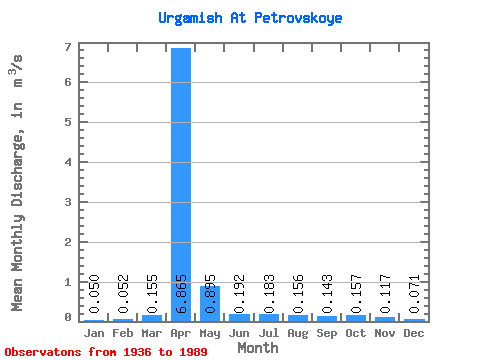
| Statistic | Jan | Feb | Mar | Apr | May | Jun | Jul | Aug | Sep | Oct | Nov | Dec | Annual |
|---|---|---|---|---|---|---|---|---|---|---|---|---|---|
| Mean | 0.05 | 0.05 | 0.15 | 6.87 | 0.90 | 0.19 | 0.18 | 0.16 | 0.14 | 0.16 | 0.12 | 0.07 | 1.03 |
| Standard Deviation | 0.04 | 0.03 | 0.13 | 7.79 | 1.55 | 0.21 | 0.22 | 0.16 | 0.15 | 0.13 | 0.08 | 0.06 | 0.98 |
| Min | 0.00 | 0.00 | 0.01 | 0.52 | 0.08 | 0.01 | 0.00 | 0.01 | 0.01 | 0.01 | 0.03 | 0.00 | 0.18 |
| Max | 0.13 | 0.13 | 0.43 | 29.90 | 8.29 | 1.12 | 1.05 | 0.60 | 0.57 | 0.62 | 0.35 | 0.27 | 3.43 |
| Coefficient of Variation | 0.69 | 0.58 | 0.83 | 1.14 | 1.74 | 1.07 | 1.18 | 1.00 | 1.07 | 0.86 | 0.70 | 0.77 | 0.96 |
 Return to R-Arctic Net Home Page