|
|
|||||||||||||||||
| Point ID: 7173 | Downloads | Plots | Site Data | Code: 12092 |
|
|
|||||||||||||||||
| Download | |
|---|---|
| Site Descriptor Information | Site Time Series Data |
| Link to all available data | |
| View: | Time Series | All |
| Units: | m3/s |
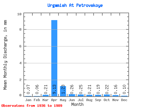
| Statistic | Jan | Feb | Mar | Apr | May | Jun | Jul | Aug | Sep | Oct | Nov | Dec | Annual |
|---|---|---|---|---|---|---|---|---|---|---|---|---|---|
| Mean | 0.07 | 0.07 | 0.21 | 9.13 | 1.23 | 0.26 | 0.25 | 0.21 | 0.19 | 0.21 | 0.16 | 0.10 | 16.63 |
| Standard Deviation | 0.05 | 0.04 | 0.18 | 10.36 | 2.13 | 0.27 | 0.30 | 0.21 | 0.20 | 0.18 | 0.11 | 0.08 | 15.91 |
| Min | 0.00 | 0.00 | 0.01 | 0.69 | 0.11 | 0.01 | 0.01 | 0.01 | 0.02 | 0.02 | 0.04 | 0.00 | 2.94 |
| Max | 0.18 | 0.16 | 0.59 | 39.74 | 11.38 | 1.49 | 1.44 | 0.82 | 0.76 | 0.85 | 0.47 | 0.37 | 55.51 |
| Coefficient of Variation | 0.69 | 0.58 | 0.83 | 1.14 | 1.74 | 1.07 | 1.18 | 1.00 | 1.07 | 0.86 | 0.70 | 0.77 | 0.96 |
 Return to R-Arctic Net Home Page