|
|
|||||||||||||||||
| Point ID: 7168 | Downloads | Plots | Site Data | Code: 12061 |
|
|
|||||||||||||||||
| Download | |
|---|---|
| Site Descriptor Information | Site Time Series Data |
| Link to all available data | |
| View: | Time Series | All |
| Units: | mm |
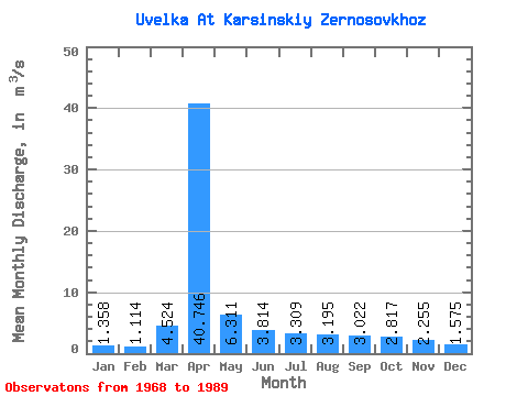
| Statistic | Jan | Feb | Mar | Apr | May | Jun | Jul | Aug | Sep | Oct | Nov | Dec | Annual |
|---|---|---|---|---|---|---|---|---|---|---|---|---|---|
| Mean | 1.36 | 1.11 | 4.52 | 40.75 | 6.31 | 3.81 | 3.31 | 3.19 | 3.02 | 2.82 | 2.25 | 1.57 | 6.26 |
| Standard Deviation | 0.60 | 0.48 | 3.41 | 26.93 | 4.15 | 2.10 | 1.87 | 1.77 | 1.88 | 1.61 | 0.98 | 0.56 | 3.19 |
| Min | 0.38 | 0.22 | 0.02 | 2.57 | 0.64 | 0.21 | 0.33 | 0.41 | 0.47 | 0.72 | 0.48 | 0.42 | 0.96 |
| Max | 2.87 | 1.90 | 10.60 | 107.00 | 16.00 | 8.23 | 7.42 | 7.06 | 7.84 | 7.97 | 4.36 | 3.09 | 12.90 |
| Coefficient of Variation | 0.44 | 0.43 | 0.75 | 0.66 | 0.66 | 0.55 | 0.57 | 0.55 | 0.62 | 0.57 | 0.43 | 0.36 | 0.51 |
 Return to R-Arctic Net Home Page