|
|
|||||||||||||||||
| Point ID: 7168 | Downloads | Plots | Site Data | Code: 12061 |
|
|
|||||||||||||||||
| Download | |
|---|---|
| Site Descriptor Information | Site Time Series Data |
| Link to all available data | |
| View: | Time Series | All |
| Units: | m3/s |
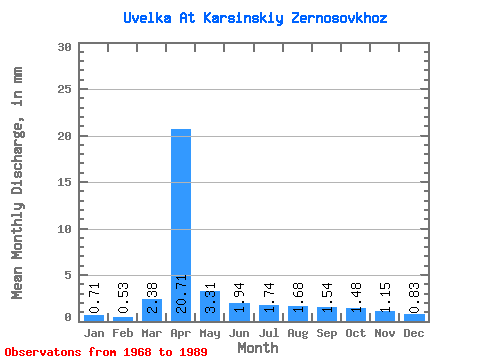
| Statistic | Jan | Feb | Mar | Apr | May | Jun | Jul | Aug | Sep | Oct | Nov | Dec | Annual |
|---|---|---|---|---|---|---|---|---|---|---|---|---|---|
| Mean | 0.71 | 0.53 | 2.38 | 20.71 | 3.31 | 1.94 | 1.74 | 1.68 | 1.54 | 1.48 | 1.15 | 0.83 | 38.73 |
| Standard Deviation | 0.32 | 0.23 | 1.79 | 13.69 | 2.18 | 1.06 | 0.98 | 0.93 | 0.96 | 0.84 | 0.50 | 0.30 | 19.77 |
| Min | 0.20 | 0.10 | 0.01 | 1.31 | 0.34 | 0.11 | 0.17 | 0.21 | 0.24 | 0.38 | 0.24 | 0.22 | 5.95 |
| Max | 1.51 | 0.91 | 5.57 | 54.38 | 8.40 | 4.18 | 3.90 | 3.71 | 3.98 | 4.18 | 2.22 | 1.62 | 79.85 |
| Coefficient of Variation | 0.44 | 0.43 | 0.75 | 0.66 | 0.66 | 0.55 | 0.57 | 0.55 | 0.62 | 0.57 | 0.43 | 0.36 | 0.51 |
 Return to R-Arctic Net Home Page