|
|
|||||||||||||||||
| Point ID: 716 | Downloads | Plots | Site Data | Code: 07DA017 |
|
|
|||||||||||||||||
| Download | |
|---|---|
| Site Descriptor Information | Site Time Series Data |
| Link to all available data | |
| View: | Time Series | All |
| Units: | mm |
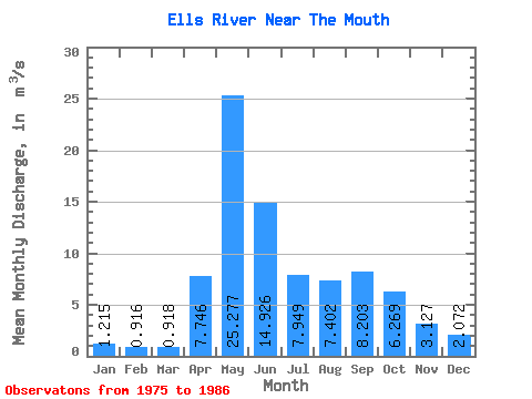
| Statistic | Jan | Feb | Mar | Apr | May | Jun | Jul | Aug | Sep | Oct | Nov | Dec | Annual |
|---|---|---|---|---|---|---|---|---|---|---|---|---|---|
| Mean | 1.22 | 0.92 | 0.92 | 7.75 | 25.28 | 14.93 | 7.95 | 7.40 | 8.20 | 6.27 | 3.13 | 2.07 | 6.86 |
| Standard Deviation | 0.61 | 0.46 | 0.50 | 5.08 | 21.86 | 12.99 | 5.84 | 5.08 | 8.61 | 5.72 | 2.04 | 1.32 | 2.84 |
| Min | 0.26 | 0.08 | 0.04 | 3.15 | 3.14 | 2.28 | 1.71 | 1.79 | 0.62 | 0.57 | 0.50 | 0.44 | 3.46 |
| Max | 2.25 | 1.70 | 1.63 | 21.50 | 76.70 | 47.00 | 21.40 | 17.90 | 26.90 | 20.70 | 6.81 | 4.51 | 10.55 |
| Coefficient of Variation | 0.50 | 0.50 | 0.54 | 0.66 | 0.86 | 0.87 | 0.73 | 0.69 | 1.05 | 0.91 | 0.65 | 0.64 | 0.41 |
 Return to R-Arctic Net Home Page