|
|
|||||||||||||||||
| Point ID: 716 | Downloads | Plots | Site Data | Code: 07DA017 |
|
|
|||||||||||||||||
| Download | |
|---|---|
| Site Descriptor Information | Site Time Series Data |
| Link to all available data | |
| View: | Time Series | All |
| Units: | m3/s |
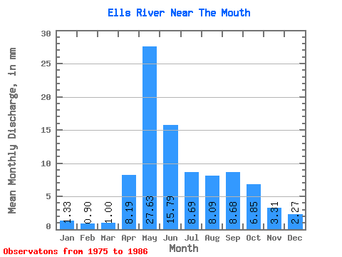
| Statistic | Jan | Feb | Mar | Apr | May | Jun | Jul | Aug | Sep | Oct | Nov | Dec | Annual |
|---|---|---|---|---|---|---|---|---|---|---|---|---|---|
| Mean | 1.33 | 0.91 | 1.00 | 8.20 | 27.63 | 15.79 | 8.69 | 8.09 | 8.68 | 6.85 | 3.31 | 2.26 | 88.40 |
| Standard Deviation | 0.66 | 0.46 | 0.54 | 5.38 | 23.89 | 13.74 | 6.38 | 5.56 | 9.11 | 6.26 | 2.16 | 1.45 | 36.62 |
| Min | 0.28 | 0.08 | 0.04 | 3.33 | 3.43 | 2.41 | 1.87 | 1.96 | 0.66 | 0.62 | 0.53 | 0.48 | 44.54 |
| Max | 2.46 | 1.69 | 1.78 | 22.75 | 83.84 | 49.72 | 23.39 | 19.57 | 28.46 | 22.63 | 7.21 | 4.93 | 135.92 |
| Coefficient of Variation | 0.50 | 0.50 | 0.54 | 0.66 | 0.86 | 0.87 | 0.73 | 0.69 | 1.05 | 0.91 | 0.65 | 0.64 | 0.41 |
 Return to R-Arctic Net Home Page