|
|
|||||||||||||||||
| Point ID: 7158 | Downloads | Plots | Site Data | Code: 12030 |
|
|
|||||||||||||||||
| Download | |
|---|---|
| Site Descriptor Information | Site Time Series Data |
| Link to all available data | |
| View: | Time Series | All |
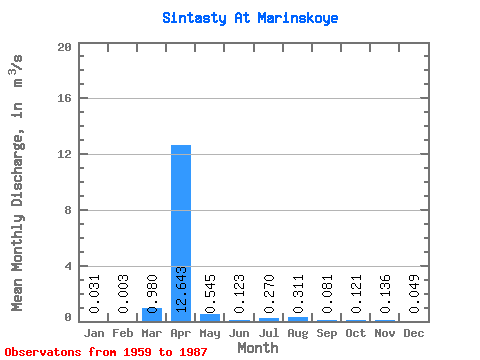
| Units: | mm |
| Statistic | Jan | Feb | Mar | Apr | May | Jun | Jul | Aug | Sep | Oct | Nov | Dec | Annual |
|---|---|---|---|---|---|---|---|---|---|---|---|---|---|
| Mean | 0.03 | 0.00 | 0.98 | 12.64 | 0.55 | 0.12 | 0.27 | 0.31 | 0.08 | 0.12 | 0.14 | 0.05 | 0.66 |
| Standard Deviation | 0.03 | 0.00 | 1.96 | 12.69 | 0.62 | 0.12 | 0.46 | 0.54 | 0.07 | 0.10 | 0.10 | 0.06 | 0.32 |
| Min | 0.00 | 0.00 | 0.00 | 0.71 | 0.05 | 0.00 | 0.01 | 0.00 | 0.00 | 0.00 | 0.00 | 0.00 | 0.36 |
| Max | 0.07 | 0.01 | 7.59 | 55.60 | 2.66 | 0.35 | 2.04 | 1.79 | 0.27 | 0.42 | 0.39 | 0.26 | 1.00 |
| Coefficient of Variation | 0.92 | 1.20 | 2.00 | 1.00 | 1.13 | 0.94 | 1.72 | 1.74 | 0.84 | 0.82 | 0.74 | 1.32 | 0.48 |
 Return to R-Arctic Net Home Page