|
|
|||||||||||||||||
| Point ID: 7158 | Downloads | Plots | Site Data | Code: 12030 |
|
|
|||||||||||||||||
| Download | |
|---|---|
| Site Descriptor Information | Site Time Series Data |
| Link to all available data | |
| View: | Time Series | All |
| Units: | m3/s |
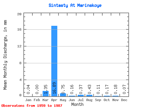
| Statistic | Jan | Feb | Mar | Apr | May | Jun | Jul | Aug | Sep | Oct | Nov | Dec | Annual |
|---|---|---|---|---|---|---|---|---|---|---|---|---|---|
| Mean | 0.04 | 0.00 | 1.35 | 16.89 | 0.75 | 0.16 | 0.37 | 0.43 | 0.11 | 0.17 | 0.18 | 0.07 | 10.72 |
| Standard Deviation | 0.04 | 0.00 | 2.71 | 16.96 | 0.85 | 0.15 | 0.64 | 0.74 | 0.09 | 0.14 | 0.13 | 0.09 | 5.20 |
| Min | 0.00 | 0.00 | 0.00 | 0.95 | 0.07 | 0.00 | 0.01 | 0.00 | 0.00 | 0.00 | 0.00 | 0.00 | 5.89 |
| Max | 0.09 | 0.01 | 10.48 | 74.29 | 3.67 | 0.47 | 2.82 | 2.47 | 0.36 | 0.58 | 0.52 | 0.36 | 16.23 |
| Coefficient of Variation | 0.92 | 1.20 | 2.00 | 1.00 | 1.13 | 0.94 | 1.72 | 1.74 | 0.84 | 0.82 | 0.74 | 1.32 | 0.48 |
 Return to R-Arctic Net Home Page