|
|
|||||||||||||||||
| Point ID: 7155 | Downloads | Plots | Site Data | Code: 12022 |
|
|
|||||||||||||||||
| Download | |
|---|---|
| Site Descriptor Information | Site Time Series Data |
| Link to all available data | |
| View: | Time Series | All |
| Units: | mm |
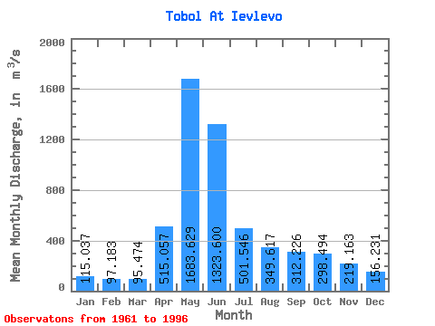
| Statistic | Jan | Feb | Mar | Apr | May | Jun | Jul | Aug | Sep | Oct | Nov | Dec | Annual |
|---|---|---|---|---|---|---|---|---|---|---|---|---|---|
| Mean | 115.04 | 97.18 | 95.47 | 515.06 | 1683.63 | 1323.60 | 501.55 | 349.62 | 312.23 | 298.49 | 219.16 | 156.23 | 472.27 |
| Standard Deviation | 46.02 | 33.81 | 33.60 | 290.82 | 980.54 | 1222.97 | 359.78 | 317.43 | 297.48 | 253.15 | 140.57 | 80.31 | 245.37 |
| Min | 48.80 | 43.50 | 47.80 | 144.00 | 327.00 | 104.00 | 78.10 | 58.80 | 47.40 | 45.80 | 53.60 | 58.50 | 122.25 |
| Max | 224.00 | 184.00 | 215.00 | 1560.00 | 4660.00 | 6790.00 | 1830.00 | 1400.00 | 1550.00 | 1100.00 | 532.00 | 378.00 | 1050.00 |
| Coefficient of Variation | 0.40 | 0.35 | 0.35 | 0.56 | 0.58 | 0.92 | 0.72 | 0.91 | 0.95 | 0.85 | 0.64 | 0.51 | 0.52 |
 Return to R-Arctic Net Home Page