|
|
|||||||||||||||||
| Point ID: 7155 | Downloads | Plots | Site Data | Code: 12022 |
|
|
|||||||||||||||||
| Download | |
|---|---|
| Site Descriptor Information | Site Time Series Data |
| Link to all available data | |
| View: | Time Series | All |
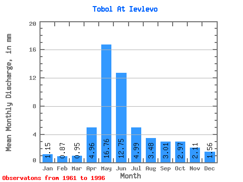
| Units: | m3/s |
| Statistic | Jan | Feb | Mar | Apr | May | Jun | Jul | Aug | Sep | Oct | Nov | Dec | Annual |
|---|---|---|---|---|---|---|---|---|---|---|---|---|---|
| Mean | 0.93 | 0.71 | 0.77 | 4.01 | 13.54 | 10.30 | 4.03 | 2.81 | 2.43 | 2.40 | 1.71 | 1.26 | 44.76 |
| Standard Deviation | 0.37 | 0.25 | 0.27 | 2.26 | 7.89 | 9.52 | 2.89 | 2.55 | 2.31 | 2.04 | 1.09 | 0.65 | 23.25 |
| Min | 0.39 | 0.32 | 0.38 | 1.12 | 2.63 | 0.81 | 0.63 | 0.47 | 0.37 | 0.37 | 0.42 | 0.47 | 11.59 |
| Max | 1.80 | 1.35 | 1.73 | 12.14 | 37.48 | 52.85 | 14.72 | 11.26 | 12.06 | 8.85 | 4.14 | 3.04 | 99.51 |
| Coefficient of Variation | 0.40 | 0.35 | 0.35 | 0.56 | 0.58 | 0.92 | 0.72 | 0.91 | 0.95 | 0.85 | 0.64 | 0.51 | 0.52 |
 Return to R-Arctic Net Home Page