|
|
|||||||||||||||||
| Point ID: 7152 | Downloads | Plots | Site Data | Code: 12014 |
|
|
|||||||||||||||||
| Download | |
|---|---|
| Site Descriptor Information | Site Time Series Data |
| Link to all available data | |
| View: | Time Series | All |
| Units: | mm |
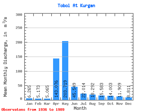
| Statistic | Jan | Feb | Mar | Apr | May | Jun | Jul | Aug | Sep | Oct | Nov | Dec | Annual |
|---|---|---|---|---|---|---|---|---|---|---|---|---|---|
| Mean | 6.26 | 5.17 | 5.07 | 143.08 | 203.72 | 45.55 | 22.01 | 18.29 | 15.58 | 14.00 | 11.91 | 8.81 | 41.85 |
| Standard Deviation | 3.90 | 3.19 | 2.93 | 242.05 | 260.76 | 41.90 | 16.76 | 15.92 | 14.57 | 10.29 | 7.92 | 5.28 | 39.65 |
| Min | 0.29 | 0.14 | 0.35 | 6.44 | 9.62 | 1.09 | 0.48 | 0.51 | 0.58 | 0.37 | 0.38 | 0.26 | 3.65 |
| Max | 17.40 | 14.40 | 12.50 | 1370.00 | 1480.00 | 246.00 | 76.10 | 79.90 | 87.00 | 61.70 | 47.90 | 25.10 | 171.12 |
| Coefficient of Variation | 0.62 | 0.62 | 0.58 | 1.69 | 1.28 | 0.92 | 0.76 | 0.87 | 0.94 | 0.73 | 0.67 | 0.60 | 0.95 |
 Return to R-Arctic Net Home Page