|
|
|||||||||||||||||
| Point ID: 7152 | Downloads | Plots | Site Data | Code: 12014 |
|
|
|||||||||||||||||
| Download | |
|---|---|
| Site Descriptor Information | Site Time Series Data |
| Link to all available data | |
| View: | Time Series | All |
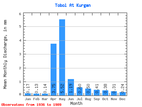
| Units: | m3/s |
| Statistic | Jan | Feb | Mar | Apr | May | Jun | Jul | Aug | Sep | Oct | Nov | Dec | Annual |
|---|---|---|---|---|---|---|---|---|---|---|---|---|---|
| Mean | 0.11 | 0.08 | 0.09 | 2.33 | 3.43 | 0.74 | 0.37 | 0.31 | 0.25 | 0.24 | 0.19 | 0.15 | 8.31 |
| Standard Deviation | 0.07 | 0.05 | 0.05 | 3.95 | 4.39 | 0.68 | 0.28 | 0.27 | 0.24 | 0.17 | 0.13 | 0.09 | 7.87 |
| Min | 0.01 | 0.00 | 0.01 | 0.10 | 0.16 | 0.02 | 0.01 | 0.01 | 0.01 | 0.01 | 0.01 | 0.00 | 0.72 |
| Max | 0.29 | 0.22 | 0.21 | 22.33 | 24.93 | 4.01 | 1.28 | 1.35 | 1.42 | 1.04 | 0.78 | 0.42 | 33.97 |
| Coefficient of Variation | 0.62 | 0.62 | 0.58 | 1.69 | 1.28 | 0.92 | 0.76 | 0.87 | 0.94 | 0.73 | 0.67 | 0.60 | 0.95 |
 Return to R-Arctic Net Home Page