|
|
|||||||||||||||||
| Point ID: 7151 | Downloads | Plots | Site Data | Code: 12010 |
|
|
|||||||||||||||||
| Download | |
|---|---|
| Site Descriptor Information | Site Time Series Data |
| Link to all available data | |
| View: | Time Series | All |
| Units: | mm |
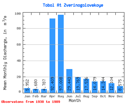
| Statistic | Jan | Feb | Mar | Apr | May | Jun | Jul | Aug | Sep | Oct | Nov | Dec | Annual |
|---|---|---|---|---|---|---|---|---|---|---|---|---|---|
| Mean | 5.95 | 4.68 | 4.79 | 92.41 | 97.01 | 29.44 | 19.77 | 17.54 | 14.08 | 14.34 | 12.10 | 8.57 | 27.32 |
| Standard Deviation | 3.57 | 2.69 | 2.80 | 81.52 | 70.88 | 16.54 | 15.33 | 15.66 | 10.87 | 8.25 | 6.48 | 5.06 | 16.00 |
| Min | 0.86 | 0.89 | 0.74 | 21.20 | 16.80 | 3.98 | 2.45 | 2.27 | 1.90 | 2.68 | 2.44 | 1.59 | 5.28 |
| Max | 15.10 | 11.40 | 10.40 | 344.00 | 327.00 | 75.40 | 85.90 | 70.70 | 51.20 | 33.70 | 25.40 | 25.50 | 76.81 |
| Coefficient of Variation | 0.60 | 0.58 | 0.58 | 0.88 | 0.73 | 0.56 | 0.78 | 0.89 | 0.77 | 0.57 | 0.54 | 0.59 | 0.59 |
 Return to R-Arctic Net Home Page