|
|
|||||||||||||||||
| Point ID: 7151 | Downloads | Plots | Site Data | Code: 12010 |
|
|
|||||||||||||||||
| Download | |
|---|---|
| Site Descriptor Information | Site Time Series Data |
| Link to all available data | |
| View: | Time Series | All |
| Units: | m3/s |
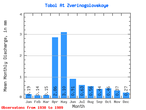
| Statistic | Jan | Feb | Mar | Apr | May | Jun | Jul | Aug | Sep | Oct | Nov | Dec | Annual |
|---|---|---|---|---|---|---|---|---|---|---|---|---|---|
| Mean | 0.11 | 0.08 | 0.09 | 1.68 | 1.82 | 0.53 | 0.37 | 0.33 | 0.26 | 0.27 | 0.22 | 0.16 | 6.03 |
| Standard Deviation | 0.07 | 0.05 | 0.05 | 1.48 | 1.33 | 0.30 | 0.29 | 0.29 | 0.20 | 0.15 | 0.12 | 0.10 | 3.53 |
| Min | 0.02 | 0.01 | 0.01 | 0.38 | 0.32 | 0.07 | 0.05 | 0.04 | 0.03 | 0.05 | 0.04 | 0.03 | 1.17 |
| Max | 0.28 | 0.20 | 0.20 | 6.24 | 6.12 | 1.37 | 1.61 | 1.32 | 0.93 | 0.63 | 0.46 | 0.48 | 16.95 |
| Coefficient of Variation | 0.60 | 0.58 | 0.58 | 0.88 | 0.73 | 0.56 | 0.78 | 0.89 | 0.77 | 0.57 | 0.54 | 0.59 | 0.59 |
 Return to R-Arctic Net Home Page