|
|
|||||||||||||||||
| Point ID: 7150 | Downloads | Plots | Site Data | Code: 12008 |
|
|
|||||||||||||||||
| Download | |
|---|---|
| Site Descriptor Information | Site Time Series Data |
| Link to all available data | |
| View: | Time Series | All |
| Units: | mm |
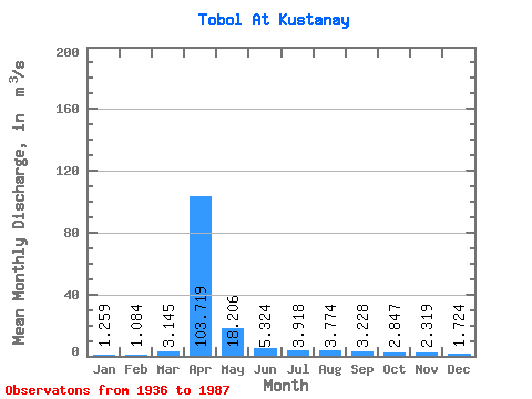
| Statistic | Jan | Feb | Mar | Apr | May | Jun | Jul | Aug | Sep | Oct | Nov | Dec | Annual |
|---|---|---|---|---|---|---|---|---|---|---|---|---|---|
| Mean | 1.26 | 1.08 | 3.15 | 103.72 | 18.21 | 5.32 | 3.92 | 3.77 | 3.23 | 2.85 | 2.32 | 1.72 | 13.09 |
| Standard Deviation | 1.12 | 0.90 | 7.78 | 159.49 | 32.60 | 4.14 | 2.83 | 3.72 | 2.86 | 2.23 | 1.78 | 1.30 | 16.68 |
| Min | 0.07 | 0.02 | 0.41 | 0.99 | 0.56 | 0.58 | 0.42 | 0.39 | 0.47 | 0.43 | 0.34 | 0.22 | 0.93 |
| Max | 6.85 | 4.58 | 52.40 | 669.00 | 220.00 | 19.40 | 14.30 | 20.60 | 14.30 | 10.90 | 8.52 | 6.72 | 64.52 |
| Coefficient of Variation | 0.89 | 0.83 | 2.47 | 1.54 | 1.79 | 0.78 | 0.72 | 0.98 | 0.89 | 0.78 | 0.77 | 0.75 | 1.27 |
 Return to R-Arctic Net Home Page