|
|
|||||||||||||||||
| Point ID: 7150 | Downloads | Plots | Site Data | Code: 12008 |
|
|
|||||||||||||||||
| Download | |
|---|---|
| Site Descriptor Information | Site Time Series Data |
| Link to all available data | |
| View: | Time Series | All |
| Units: | m3/s |
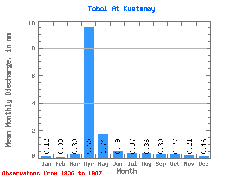
| Statistic | Jan | Feb | Mar | Apr | May | Jun | Jul | Aug | Sep | Oct | Nov | Dec | Annual |
|---|---|---|---|---|---|---|---|---|---|---|---|---|---|
| Mean | 0.07 | 0.06 | 0.19 | 6.00 | 1.09 | 0.31 | 0.23 | 0.23 | 0.19 | 0.17 | 0.13 | 0.10 | 9.22 |
| Standard Deviation | 0.07 | 0.05 | 0.47 | 9.23 | 1.95 | 0.24 | 0.17 | 0.22 | 0.17 | 0.13 | 0.10 | 0.08 | 11.75 |
| Min | 0.00 | 0.00 | 0.03 | 0.06 | 0.03 | 0.03 | 0.03 | 0.02 | 0.03 | 0.03 | 0.02 | 0.01 | 0.66 |
| Max | 0.41 | 0.25 | 3.13 | 38.71 | 13.15 | 1.12 | 0.85 | 1.23 | 0.83 | 0.65 | 0.49 | 0.40 | 45.45 |
| Coefficient of Variation | 0.89 | 0.83 | 2.47 | 1.54 | 1.79 | 0.78 | 0.72 | 0.98 | 0.89 | 0.78 | 0.77 | 0.75 | 1.27 |
 Return to R-Arctic Net Home Page