|
|
|||||||||||||||||
| Point ID: 7149 | Downloads | Plots | Site Data | Code: 12007 |
|
|
|||||||||||||||||
| Download | |
|---|---|
| Site Descriptor Information | Site Time Series Data |
| Link to all available data | |
| View: | Time Series | All |
| Units: | mm |
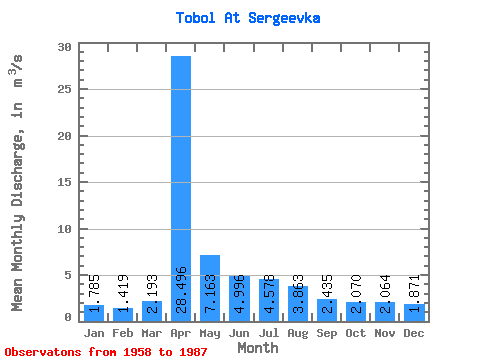
| Statistic | Jan | Feb | Mar | Apr | May | Jun | Jul | Aug | Sep | Oct | Nov | Dec | Annual |
|---|---|---|---|---|---|---|---|---|---|---|---|---|---|
| Mean | 1.79 | 1.42 | 2.19 | 28.50 | 7.16 | 5.00 | 4.58 | 3.86 | 2.44 | 2.07 | 2.06 | 1.87 | 5.55 |
| Standard Deviation | 0.96 | 0.59 | 2.03 | 40.58 | 8.55 | 1.90 | 2.40 | 2.45 | 1.20 | 1.18 | 1.04 | 0.99 | 4.65 |
| Min | 0.36 | 0.44 | 0.44 | 1.21 | 1.05 | 2.52 | 1.74 | 0.72 | 0.60 | 0.58 | 0.44 | 0.27 | 1.73 |
| Max | 4.35 | 2.52 | 9.90 | 123.00 | 32.90 | 9.21 | 10.40 | 12.20 | 4.75 | 5.84 | 5.19 | 4.64 | 17.17 |
| Coefficient of Variation | 0.54 | 0.42 | 0.93 | 1.42 | 1.19 | 0.38 | 0.53 | 0.63 | 0.49 | 0.57 | 0.51 | 0.53 | 0.84 |
 Return to R-Arctic Net Home Page