|
|
|||||||||||||||||
| Point ID: 7149 | Downloads | Plots | Site Data | Code: 12007 |
|
|
|||||||||||||||||
| Download | |
|---|---|
| Site Descriptor Information | Site Time Series Data |
| Link to all available data | |
| View: | Time Series | All |
| Units: | m3/s |
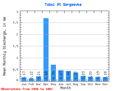
| Statistic | Jan | Feb | Mar | Apr | May | Jun | Jul | Aug | Sep | Oct | Nov | Dec | Annual |
|---|---|---|---|---|---|---|---|---|---|---|---|---|---|
| Mean | 0.16 | 0.11 | 0.19 | 2.41 | 0.63 | 0.42 | 0.40 | 0.34 | 0.21 | 0.18 | 0.17 | 0.16 | 5.72 |
| Standard Deviation | 0.08 | 0.05 | 0.18 | 3.44 | 0.75 | 0.16 | 0.21 | 0.21 | 0.10 | 0.10 | 0.09 | 0.09 | 4.79 |
| Min | 0.03 | 0.04 | 0.04 | 0.10 | 0.09 | 0.21 | 0.15 | 0.06 | 0.05 | 0.05 | 0.04 | 0.02 | 1.78 |
| Max | 0.38 | 0.20 | 0.87 | 10.42 | 2.88 | 0.78 | 0.91 | 1.07 | 0.40 | 0.51 | 0.44 | 0.41 | 17.70 |
| Coefficient of Variation | 0.54 | 0.42 | 0.93 | 1.42 | 1.19 | 0.38 | 0.53 | 0.63 | 0.49 | 0.57 | 0.51 | 0.53 | 0.84 |
 Return to R-Arctic Net Home Page