|
|
|||||||||||||||||
| Point ID: 7148 | Downloads | Plots | Site Data | Code: 12005 |
|
|
|||||||||||||||||
| Download | |
|---|---|
| Site Descriptor Information | Site Time Series Data |
| Link to all available data | |
| View: | Time Series | All |
| Units: | mm |
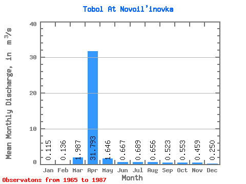
| Statistic | Jan | Feb | Mar | Apr | May | Jun | Jul | Aug | Sep | Oct | Nov | Dec | Annual |
|---|---|---|---|---|---|---|---|---|---|---|---|---|---|
| Mean | 0.12 | 0.14 | 1.99 | 31.79 | 1.65 | 0.67 | 0.69 | 0.66 | 0.52 | 0.55 | 0.46 | 0.25 | 2.44 |
| Standard Deviation | 0.11 | 0.14 | 3.27 | 38.42 | 2.02 | 0.36 | 0.60 | 0.72 | 0.44 | 0.30 | 0.23 | 0.14 | 0.59 |
| Min | 0.00 | 0.00 | 0.02 | 0.61 | 0.26 | 0.12 | 0.21 | 0.18 | 0.08 | 0.24 | 0.17 | 0.03 | 2.02 |
| Max | 0.25 | 0.32 | 5.76 | 101.00 | 7.22 | 1.18 | 1.91 | 2.44 | 1.68 | 1.51 | 0.92 | 0.56 | 2.86 |
| Coefficient of Variation | 0.95 | 1.00 | 1.65 | 1.21 | 1.23 | 0.55 | 0.86 | 1.09 | 0.84 | 0.54 | 0.51 | 0.57 | 0.24 |
 Return to R-Arctic Net Home Page