|
|
|||||||||||||||||
| Point ID: 7148 | Downloads | Plots | Site Data | Code: 12005 |
|
|
|||||||||||||||||
| Download | |
|---|---|
| Site Descriptor Information | Site Time Series Data |
| Link to all available data | |
| View: | Time Series | All |
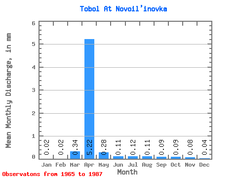
| Units: | m3/s |
| Statistic | Jan | Feb | Mar | Apr | May | Jun | Jul | Aug | Sep | Oct | Nov | Dec | Annual |
|---|---|---|---|---|---|---|---|---|---|---|---|---|---|
| Mean | 0.02 | 0.02 | 0.33 | 5.12 | 0.27 | 0.11 | 0.12 | 0.11 | 0.08 | 0.09 | 0.07 | 0.04 | 4.79 |
| Standard Deviation | 0.02 | 0.02 | 0.54 | 6.18 | 0.34 | 0.06 | 0.10 | 0.12 | 0.07 | 0.05 | 0.04 | 0.02 | 1.16 |
| Min | 0.00 | 0.00 | 0.00 | 0.10 | 0.04 | 0.02 | 0.04 | 0.03 | 0.01 | 0.04 | 0.03 | 0.01 | 3.97 |
| Max | 0.04 | 0.05 | 0.96 | 16.26 | 1.20 | 0.19 | 0.32 | 0.41 | 0.27 | 0.25 | 0.15 | 0.09 | 5.61 |
| Coefficient of Variation | 0.95 | 1.00 | 1.65 | 1.21 | 1.23 | 0.55 | 0.86 | 1.09 | 0.84 | 0.54 | 0.51 | 0.57 | 0.24 |
 Return to R-Arctic Net Home Page