|
|
|||||||||||||||||
| Point ID: 7147 | Downloads | Plots | Site Data | Code: 12002 |
|
|
|||||||||||||||||
| Download | |
|---|---|
| Site Descriptor Information | Site Time Series Data |
| Link to all available data | |
| View: | Time Series | All |
| Units: | mm |
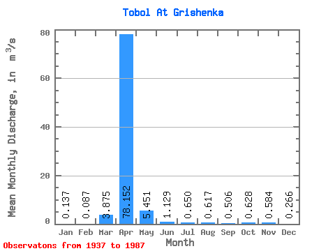
| Statistic | Jan | Feb | Mar | Apr | May | Jun | Jul | Aug | Sep | Oct | Nov | Dec | Annual |
|---|---|---|---|---|---|---|---|---|---|---|---|---|---|
| Mean | 0.14 | 0.09 | 3.88 | 78.15 | 5.45 | 1.13 | 0.65 | 0.62 | 0.51 | 0.63 | 0.58 | 0.27 | 8.40 |
| Standard Deviation | 0.14 | 0.08 | 15.19 | 99.11 | 9.63 | 1.40 | 0.86 | 1.02 | 0.75 | 0.78 | 0.89 | 0.50 | 9.14 |
| Min | 0.00 | 0.00 | 0.00 | 0.78 | 0.10 | 0.01 | 0.01 | 0.00 | 0.00 | 0.01 | 0.03 | 0.00 | 0.83 |
| Max | 0.56 | 0.25 | 80.20 | 442.00 | 60.50 | 6.75 | 4.45 | 4.56 | 4.02 | 3.22 | 5.20 | 3.28 | 32.23 |
| Coefficient of Variation | 1.04 | 0.92 | 3.92 | 1.27 | 1.77 | 1.24 | 1.33 | 1.66 | 1.48 | 1.24 | 1.52 | 1.87 | 1.09 |
 Return to R-Arctic Net Home Page