|
|
|||||||||||||||||
| Point ID: 7147 | Downloads | Plots | Site Data | Code: 12002 |
|
|
|||||||||||||||||
| Download | |
|---|---|
| Site Descriptor Information | Site Time Series Data |
| Link to all available data | |
| View: | Time Series | All |
| Units: | m3/s |
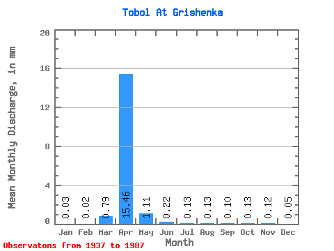
| Statistic | Jan | Feb | Mar | Apr | May | Jun | Jul | Aug | Sep | Oct | Nov | Dec | Annual |
|---|---|---|---|---|---|---|---|---|---|---|---|---|---|
| Mean | 0.03 | 0.02 | 0.77 | 15.12 | 1.09 | 0.22 | 0.13 | 0.12 | 0.10 | 0.12 | 0.11 | 0.05 | 19.77 |
| Standard Deviation | 0.03 | 0.01 | 3.04 | 19.17 | 1.92 | 0.27 | 0.17 | 0.20 | 0.14 | 0.16 | 0.17 | 0.10 | 21.52 |
| Min | 0.00 | 0.00 | 0.00 | 0.15 | 0.02 | 0.00 | 0.00 | 0.00 | 0.00 | 0.00 | 0.01 | 0.00 | 1.95 |
| Max | 0.11 | 0.05 | 16.03 | 85.50 | 12.09 | 1.31 | 0.89 | 0.91 | 0.78 | 0.64 | 1.01 | 0.66 | 75.90 |
| Coefficient of Variation | 1.04 | 0.92 | 3.92 | 1.27 | 1.77 | 1.24 | 1.33 | 1.66 | 1.48 | 1.24 | 1.52 | 1.87 | 1.09 |
 Return to R-Arctic Net Home Page