|
|
|||||||||||||||||
| Point ID: 7121 | Downloads | Plots | Site Data | Code: 11580 |
|
|
|||||||||||||||||
| Download | |
|---|---|
| Site Descriptor Information | Site Time Series Data |
| Link to all available data | |
| View: | Time Series | All |
| Units: | mm |
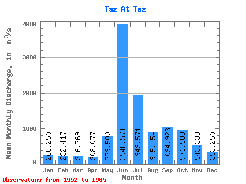
| Statistic | Jan | Feb | Mar | Apr | May | Jun | Jul | Aug | Sep | Oct | Nov | Dec | Annual |
|---|---|---|---|---|---|---|---|---|---|---|---|---|---|
| Mean | 268.25 | 232.42 | 216.77 | 208.08 | 779.50 | 3948.57 | 1943.57 | 915.15 | 1034.92 | 971.58 | 543.33 | 353.25 | 904.42 |
| Standard Deviation | 52.05 | 34.22 | 27.71 | 19.88 | 460.34 | 719.98 | 664.00 | 184.07 | 356.57 | 280.40 | 151.21 | 92.02 | 110.16 |
| Min | 194.00 | 175.00 | 165.00 | 176.00 | 255.00 | 2830.00 | 1180.00 | 570.00 | 541.00 | 575.00 | 313.00 | 237.00 | 727.00 |
| Max | 351.00 | 293.00 | 262.00 | 243.00 | 1850.00 | 5130.00 | 3550.00 | 1180.00 | 1800.00 | 1460.00 | 780.00 | 493.00 | 1085.75 |
| Coefficient of Variation | 0.19 | 0.15 | 0.13 | 0.10 | 0.59 | 0.18 | 0.34 | 0.20 | 0.34 | 0.29 | 0.28 | 0.26 | 0.12 |
 Return to R-Arctic Net Home Page