|
|
|||||||||||||||||
| Point ID: 7121 | Downloads | Plots | Site Data | Code: 11580 |
|
|
|||||||||||||||||
| Download | |
|---|---|
| Site Descriptor Information | Site Time Series Data |
| Link to all available data | |
| View: | Time Series | All |
| Units: | m3/s |
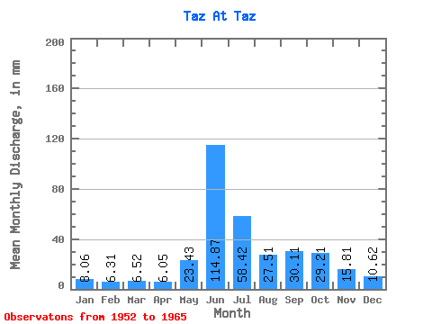
| Statistic | Jan | Feb | Mar | Apr | May | Jun | Jul | Aug | Sep | Oct | Nov | Dec | Annual |
|---|---|---|---|---|---|---|---|---|---|---|---|---|---|
| Mean | 8.06 | 6.37 | 6.51 | 6.05 | 23.43 | 114.87 | 58.42 | 27.51 | 30.11 | 29.20 | 15.81 | 10.62 | 320.36 |
| Standard Deviation | 1.56 | 0.94 | 0.83 | 0.58 | 13.84 | 20.95 | 19.96 | 5.53 | 10.37 | 8.43 | 4.40 | 2.77 | 39.02 |
| Min | 5.83 | 4.79 | 4.96 | 5.12 | 7.66 | 82.33 | 35.47 | 17.13 | 15.74 | 17.28 | 9.11 | 7.12 | 257.51 |
| Max | 10.55 | 8.02 | 7.88 | 7.07 | 55.60 | 149.24 | 106.70 | 35.47 | 52.36 | 43.88 | 22.69 | 14.82 | 384.58 |
| Coefficient of Variation | 0.19 | 0.15 | 0.13 | 0.10 | 0.59 | 0.18 | 0.34 | 0.20 | 0.34 | 0.29 | 0.28 | 0.26 | 0.12 |
 Return to R-Arctic Net Home Page