|
|
|||||||||||||||||
| Point ID: 7082 | Downloads | Plots | Site Data | Code: 11495 |
|
|
|||||||||||||||||
| Download | |
|---|---|
| Site Descriptor Information | Site Time Series Data |
| Link to all available data | |
| View: | Time Series | All |
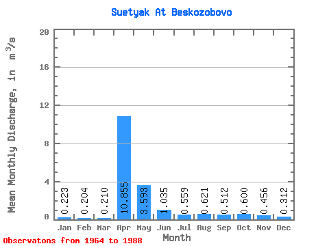
| Units: | mm |
| Statistic | Jan | Feb | Mar | Apr | May | Jun | Jul | Aug | Sep | Oct | Nov | Dec | Annual |
|---|---|---|---|---|---|---|---|---|---|---|---|---|---|
| Mean | 0.22 | 0.20 | 0.21 | 10.86 | 3.59 | 1.03 | 0.56 | 0.62 | 0.51 | 0.60 | 0.46 | 0.31 | 1.62 |
| Standard Deviation | 0.12 | 0.12 | 0.09 | 7.28 | 3.92 | 1.59 | 0.53 | 0.94 | 0.60 | 0.58 | 0.30 | 0.16 | 1.10 |
| Min | 0.00 | 0.00 | 0.00 | 2.27 | 0.79 | 0.08 | 0.04 | 0.16 | 0.15 | 0.18 | 0.12 | 0.09 | 0.43 |
| Max | 0.53 | 0.56 | 0.37 | 31.00 | 17.00 | 7.85 | 2.20 | 4.65 | 2.94 | 2.84 | 1.50 | 0.77 | 3.78 |
| Coefficient of Variation | 0.54 | 0.60 | 0.45 | 0.67 | 1.09 | 1.53 | 0.95 | 1.51 | 1.17 | 0.97 | 0.66 | 0.52 | 0.68 |
 Return to R-Arctic Net Home Page