|
|
|||||||||||||||||
| Point ID: 7082 | Downloads | Plots | Site Data | Code: 11495 |
|
|
|||||||||||||||||
| Download | |
|---|---|
| Site Descriptor Information | Site Time Series Data |
| Link to all available data | |
| View: | Time Series | All |
| Units: | m3/s |
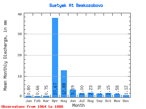
| Statistic | Jan | Feb | Mar | Apr | May | Jun | Jul | Aug | Sep | Oct | Nov | Dec | Annual |
|---|---|---|---|---|---|---|---|---|---|---|---|---|---|
| Mean | 0.80 | 0.67 | 0.75 | 37.66 | 12.88 | 3.59 | 2.00 | 2.23 | 1.78 | 2.15 | 1.58 | 1.12 | 68.41 |
| Standard Deviation | 0.43 | 0.40 | 0.34 | 25.27 | 14.04 | 5.51 | 1.90 | 3.37 | 2.07 | 2.09 | 1.04 | 0.58 | 46.64 |
| Min | 0.00 | 0.00 | 0.00 | 7.88 | 2.83 | 0.29 | 0.15 | 0.57 | 0.52 | 0.65 | 0.42 | 0.31 | 18.21 |
| Max | 1.90 | 1.83 | 1.33 | 107.57 | 60.95 | 27.24 | 7.89 | 16.67 | 10.20 | 10.18 | 5.21 | 2.76 | 159.70 |
| Coefficient of Variation | 0.54 | 0.60 | 0.45 | 0.67 | 1.09 | 1.53 | 0.95 | 1.51 | 1.17 | 0.97 | 0.66 | 0.52 | 0.68 |
 Return to R-Arctic Net Home Page