|
|
|||||||||||||||||
| Point ID: 7081 | Downloads | Plots | Site Data | Code: 11493 |
|
|
|||||||||||||||||
| Download | |
|---|---|
| Site Descriptor Information | Site Time Series Data |
| Link to all available data | |
| View: | Time Series | All |
| Units: | mm |
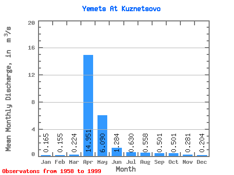
| Statistic | Jan | Feb | Mar | Apr | May | Jun | Jul | Aug | Sep | Oct | Nov | Dec | Annual |
|---|---|---|---|---|---|---|---|---|---|---|---|---|---|
| Mean | 0.17 | 0.15 | 0.22 | 14.95 | 6.09 | 1.28 | 0.63 | 0.56 | 0.50 | 0.50 | 0.28 | 0.20 | 2.16 |
| Standard Deviation | 0.09 | 0.08 | 0.18 | 12.94 | 7.23 | 1.26 | 0.69 | 0.68 | 0.88 | 0.75 | 0.18 | 0.12 | 1.73 |
| Min | 0.03 | 0.01 | 0.05 | 2.65 | 0.21 | 0.07 | 0.04 | 0.03 | 0.04 | 0.10 | 0.05 | 0.06 | 0.39 |
| Max | 0.44 | 0.41 | 1.15 | 72.40 | 35.40 | 5.54 | 2.88 | 3.08 | 5.30 | 4.59 | 0.92 | 0.62 | 8.65 |
| Coefficient of Variation | 0.57 | 0.51 | 0.81 | 0.86 | 1.19 | 0.98 | 1.09 | 1.22 | 1.76 | 1.50 | 0.63 | 0.59 | 0.80 |
 Return to R-Arctic Net Home Page