|
|
|||||||||||||||||
| Point ID: 7081 | Downloads | Plots | Site Data | Code: 11493 |
|
|
|||||||||||||||||
| Download | |
|---|---|
| Site Descriptor Information | Site Time Series Data |
| Link to all available data | |
| View: | Time Series | All |
| Units: | m3/s |
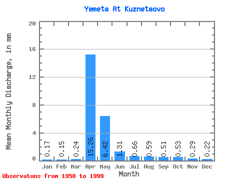
| Statistic | Jan | Feb | Mar | Apr | May | Jun | Jul | Aug | Sep | Oct | Nov | Dec | Annual |
|---|---|---|---|---|---|---|---|---|---|---|---|---|---|
| Mean | 0.17 | 0.15 | 0.24 | 15.26 | 6.42 | 1.31 | 0.66 | 0.59 | 0.51 | 0.53 | 0.29 | 0.21 | 26.86 |
| Standard Deviation | 0.10 | 0.08 | 0.19 | 13.20 | 7.62 | 1.29 | 0.73 | 0.71 | 0.90 | 0.79 | 0.18 | 0.13 | 21.45 |
| Min | 0.03 | 0.01 | 0.05 | 2.70 | 0.22 | 0.07 | 0.04 | 0.03 | 0.04 | 0.10 | 0.05 | 0.06 | 4.78 |
| Max | 0.46 | 0.39 | 1.21 | 73.88 | 37.32 | 5.65 | 3.04 | 3.25 | 5.41 | 4.84 | 0.94 | 0.65 | 107.47 |
| Coefficient of Variation | 0.57 | 0.51 | 0.81 | 0.86 | 1.19 | 0.98 | 1.09 | 1.22 | 1.76 | 1.50 | 0.63 | 0.59 | 0.80 |
 Return to R-Arctic Net Home Page