|
|
|||||||||||||||||
| Point ID: 708 | Downloads | Plots | Site Data | Code: 07DA009 |
|
|
|||||||||||||||||
| Download | |
|---|---|
| Site Descriptor Information | Site Time Series Data |
| Link to all available data | |
| View: | Time Series | All |
| Units: | mm |
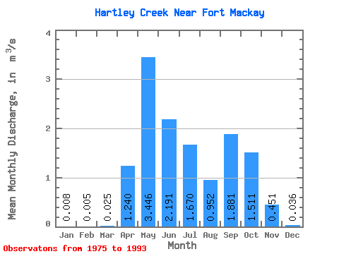
| Statistic | Jan | Feb | Mar | Apr | May | Jun | Jul | Aug | Sep | Oct | Nov | Dec | Annual |
|---|---|---|---|---|---|---|---|---|---|---|---|---|---|
| Mean | 0.01 | 0.01 | 0.03 | 1.24 | 3.45 | 2.19 | 1.67 | 0.95 | 1.88 | 1.51 | 0.45 | 0.04 | 0.85 |
| Standard Deviation | 0.01 | 0.01 | 0.03 | 1.06 | 3.17 | 1.83 | 1.77 | 0.89 | 2.57 | 1.51 | 0.39 | 0.05 | 0.55 |
| Min | 0.00 | 0.00 | 0.00 | 0.10 | 0.20 | 0.02 | 0.03 | 0.07 | 0.01 | 0.03 | 0.00 | 0.00 | 0.15 |
| Max | 0.03 | 0.02 | 0.10 | 3.93 | 9.86 | 6.71 | 6.57 | 2.98 | 9.22 | 5.69 | 1.11 | 0.15 | 1.97 |
| Coefficient of Variation | 1.20 | 1.29 | 1.01 | 0.85 | 0.92 | 0.84 | 1.06 | 0.94 | 1.36 | 1.00 | 0.86 | 1.31 | 0.65 |
 Return to R-Arctic Net Home Page