|
|
|||||||||||||||||
| Point ID: 708 | Downloads | Plots | Site Data | Code: 07DA009 |
|
|
|||||||||||||||||
| Download | |
|---|---|
| Site Descriptor Information | Site Time Series Data |
| Link to all available data | |
| View: | Time Series | All |
| Units: | m3/s |
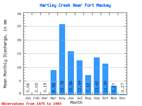
| Statistic | Jan | Feb | Mar | Apr | May | Jun | Jul | Aug | Sep | Oct | Nov | Dec | Annual |
|---|---|---|---|---|---|---|---|---|---|---|---|---|---|
| Mean | 0.06 | 0.04 | 0.19 | 8.97 | 25.78 | 15.86 | 12.49 | 7.12 | 13.62 | 11.31 | 3.26 | 0.27 | 75.06 |
| Standard Deviation | 0.07 | 0.05 | 0.19 | 7.67 | 23.74 | 13.27 | 13.20 | 6.68 | 18.58 | 11.31 | 2.80 | 0.36 | 48.74 |
| Min | 0.00 | 0.00 | 0.00 | 0.75 | 1.51 | 0.14 | 0.22 | 0.52 | 0.04 | 0.20 | 0.01 | 0.00 | 13.28 |
| Max | 0.22 | 0.16 | 0.79 | 28.45 | 73.76 | 48.58 | 49.15 | 22.29 | 66.75 | 42.56 | 8.04 | 1.15 | 173.50 |
| Coefficient of Variation | 1.20 | 1.29 | 1.01 | 0.85 | 0.92 | 0.84 | 1.06 | 0.94 | 1.36 | 1.00 | 0.86 | 1.31 | 0.65 |
 Return to R-Arctic Net Home Page