|
|
|||||||||||||||||
| Point ID: 7070 | Downloads | Plots | Site Data | Code: 11461 |
|
|
|||||||||||||||||
| Download | |
|---|---|
| Site Descriptor Information | Site Time Series Data |
| Link to all available data | |
| View: | Time Series | All |
| Units: | mm |
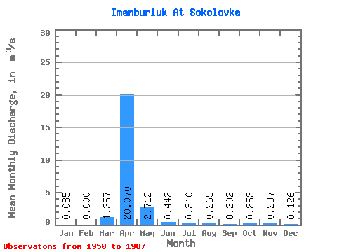
| Statistic | Jan | Feb | Mar | Apr | May | Jun | Jul | Aug | Sep | Oct | Nov | Dec | Annual |
|---|---|---|---|---|---|---|---|---|---|---|---|---|---|
| Mean | 0.09 | 0.00 | 1.26 | 20.07 | 2.71 | 0.44 | 0.31 | 0.27 | 0.20 | 0.25 | 0.24 | 0.13 | 3.00 |
| Standard Deviation | 0.08 | 0.00 | 2.76 | 15.10 | 2.83 | 0.41 | 0.37 | 0.43 | 0.14 | 0.13 | 0.15 | 0.14 | 2.94 |
| Min | 0.00 | 0.00 | 0.00 | 1.93 | 0.30 | 0.07 | 0.06 | 0.04 | 0.04 | 0.07 | 0.04 | 0.00 | 0.92 |
| Max | 0.27 | 0.00 | 11.40 | 66.10 | 15.30 | 2.16 | 1.74 | 2.30 | 0.61 | 0.63 | 0.61 | 0.61 | 5.08 |
| Coefficient of Variation | 0.96 | 2.20 | 0.75 | 1.04 | 0.93 | 1.19 | 1.63 | 0.68 | 0.53 | 0.65 | 1.13 | 0.98 |
 Return to R-Arctic Net Home Page