|
|
|||||||||||||||||
| Point ID: 7070 | Downloads | Plots | Site Data | Code: 11461 |
|
|
|||||||||||||||||
| Download | |
|---|---|
| Site Descriptor Information | Site Time Series Data |
| Link to all available data | |
| View: | Time Series | All |
| Units: | m3/s |
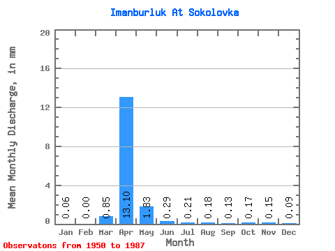
| Statistic | Jan | Feb | Mar | Apr | May | Jun | Jul | Aug | Sep | Oct | Nov | Dec | Annual |
|---|---|---|---|---|---|---|---|---|---|---|---|---|---|
| Mean | 0.06 | 0.00 | 0.83 | 12.78 | 1.78 | 0.28 | 0.20 | 0.17 | 0.13 | 0.17 | 0.15 | 0.08 | 23.26 |
| Standard Deviation | 0.05 | 0.00 | 1.82 | 9.62 | 1.86 | 0.26 | 0.24 | 0.28 | 0.09 | 0.09 | 0.10 | 0.09 | 22.77 |
| Min | 0.00 | 0.00 | 0.00 | 1.23 | 0.20 | 0.05 | 0.04 | 0.02 | 0.03 | 0.04 | 0.02 | 0.00 | 7.15 |
| Max | 0.18 | 0.00 | 7.50 | 42.10 | 10.07 | 1.38 | 1.15 | 1.51 | 0.39 | 0.41 | 0.39 | 0.40 | 39.36 |
| Coefficient of Variation | 0.96 | 2.20 | 0.75 | 1.04 | 0.93 | 1.19 | 1.63 | 0.68 | 0.53 | 0.65 | 1.13 | 0.98 |
 Return to R-Arctic Net Home Page