|
|
|||||||||||||||||
| Point ID: 707 | Downloads | Plots | Site Data | Code: 07DA008 |
|
|
|||||||||||||||||
| Download | |
|---|---|
| Site Descriptor Information | Site Time Series Data |
| Link to all available data | |
| View: | Time Series | All |
| Units: | mm |
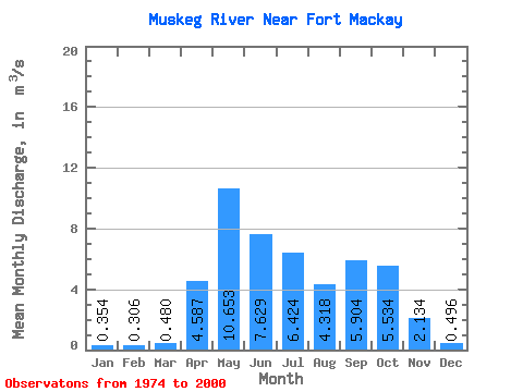
| Statistic | Jan | Feb | Mar | Apr | May | Jun | Jul | Aug | Sep | Oct | Nov | Dec | Annual |
|---|---|---|---|---|---|---|---|---|---|---|---|---|---|
| Mean | 0.35 | 0.31 | 0.48 | 4.59 | 10.65 | 7.63 | 6.42 | 4.32 | 5.90 | 5.53 | 2.13 | 0.50 | 3.61 |
| Standard Deviation | 0.16 | 0.12 | 0.31 | 3.54 | 9.27 | 5.41 | 4.98 | 4.76 | 6.82 | 5.84 | 1.62 | 0.28 | 1.80 |
| Min | 0.05 | 0.08 | 0.18 | 0.95 | 0.62 | 0.66 | 0.74 | 0.35 | 0.17 | 0.37 | 0.38 | 0.15 | 0.97 |
| Max | 0.65 | 0.49 | 1.60 | 16.60 | 34.30 | 19.50 | 14.40 | 21.00 | 22.10 | 21.00 | 5.72 | 1.16 | 6.29 |
| Coefficient of Variation | 0.45 | 0.39 | 0.64 | 0.77 | 0.87 | 0.71 | 0.78 | 1.10 | 1.16 | 1.05 | 0.76 | 0.56 | 0.50 |
 Return to R-Arctic Net Home Page