|
|
|||||||||||||||||
| Point ID: 707 | Downloads | Plots | Site Data | Code: 07DA008 |
|
|
|||||||||||||||||
| Download | |
|---|---|
| Site Descriptor Information | Site Time Series Data |
| Link to all available data | |
| View: | Time Series | All |
| Units: | m3/s |
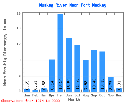
| Statistic | Jan | Feb | Mar | Apr | May | Jun | Jul | Aug | Sep | Oct | Nov | Dec | Annual |
|---|---|---|---|---|---|---|---|---|---|---|---|---|---|
| Mean | 0.65 | 0.51 | 0.88 | 8.14 | 19.54 | 13.54 | 11.78 | 7.92 | 10.48 | 10.15 | 3.79 | 0.91 | 77.97 |
| Standard Deviation | 0.29 | 0.20 | 0.56 | 6.28 | 17.01 | 9.61 | 9.13 | 8.74 | 12.11 | 10.71 | 2.88 | 0.51 | 38.98 |
| Min | 0.09 | 0.14 | 0.33 | 1.69 | 1.14 | 1.17 | 1.36 | 0.65 | 0.30 | 0.68 | 0.67 | 0.28 | 20.91 |
| Max | 1.19 | 0.82 | 2.94 | 29.47 | 62.91 | 34.62 | 26.41 | 38.52 | 39.23 | 38.52 | 10.15 | 2.13 | 135.91 |
| Coefficient of Variation | 0.45 | 0.39 | 0.64 | 0.77 | 0.87 | 0.71 | 0.78 | 1.10 | 1.16 | 1.05 | 0.76 | 0.56 | 0.50 |
 Return to R-Arctic Net Home Page