|
|
|||||||||||||||||
| Point ID: 7063 | Downloads | Plots | Site Data | Code: 11432 |
|
|
|||||||||||||||||
| Download | |
|---|---|
| Site Descriptor Information | Site Time Series Data |
| Link to all available data | |
| View: | Time Series | All |
| Units: | mm |
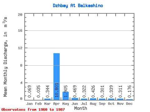
| Statistic | Jan | Feb | Mar | Apr | May | Jun | Jul | Aug | Sep | Oct | Nov | Dec | Annual |
|---|---|---|---|---|---|---|---|---|---|---|---|---|---|
| Mean | 0.07 | 0.04 | 0.34 | 10.80 | 1.91 | 0.47 | 0.32 | 0.43 | 0.30 | 0.34 | 0.31 | 0.18 | 1.47 |
| Standard Deviation | 0.06 | 0.03 | 0.72 | 6.22 | 2.41 | 0.23 | 0.23 | 0.74 | 0.17 | 0.16 | 0.19 | 0.14 | 0.53 |
| Min | 0.00 | 0.00 | 0.00 | 2.13 | 0.33 | 0.12 | 0.12 | 0.13 | 0.13 | 0.17 | 0.10 | 0.00 | 0.88 |
| Max | 0.18 | 0.08 | 2.59 | 26.70 | 9.88 | 1.02 | 1.24 | 4.06 | 0.97 | 0.95 | 0.79 | 0.64 | 2.39 |
| Coefficient of Variation | 0.83 | 0.83 | 2.10 | 0.58 | 1.27 | 0.49 | 0.73 | 1.74 | 0.57 | 0.47 | 0.61 | 0.80 | 0.36 |
 Return to R-Arctic Net Home Page