|
|
|||||||||||||||||
| Point ID: 7063 | Downloads | Plots | Site Data | Code: 11432 |
|
|
|||||||||||||||||
| Download | |
|---|---|
| Site Descriptor Information | Site Time Series Data |
| Link to all available data | |
| View: | Time Series | All |
| Units: | m3/s |
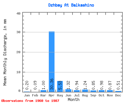
| Statistic | Jan | Feb | Mar | Apr | May | Jun | Jul | Aug | Sep | Oct | Nov | Dec | Annual |
|---|---|---|---|---|---|---|---|---|---|---|---|---|---|
| Mean | 0.20 | 0.09 | 1.00 | 30.37 | 5.53 | 1.32 | 0.94 | 1.24 | 0.85 | 0.98 | 0.87 | 0.51 | 50.26 |
| Standard Deviation | 0.17 | 0.08 | 2.10 | 17.48 | 7.00 | 0.65 | 0.68 | 2.15 | 0.49 | 0.46 | 0.54 | 0.41 | 18.07 |
| Min | 0.00 | 0.00 | 0.00 | 5.99 | 0.96 | 0.34 | 0.35 | 0.38 | 0.36 | 0.49 | 0.28 | 0.00 | 30.25 |
| Max | 0.52 | 0.21 | 7.52 | 75.06 | 28.70 | 2.87 | 3.60 | 11.79 | 2.73 | 2.76 | 2.22 | 1.86 | 81.86 |
| Coefficient of Variation | 0.83 | 0.83 | 2.10 | 0.58 | 1.27 | 0.49 | 0.73 | 1.74 | 0.57 | 0.47 | 0.61 | 0.80 | 0.36 |
 Return to R-Arctic Net Home Page