|
|
|||||||||||||||||
| Point ID: 7062 | Downloads | Plots | Site Data | Code: 11429 |
|
|
|||||||||||||||||
| Download | |
|---|---|
| Site Descriptor Information | Site Time Series Data |
| Link to all available data | |
| View: | Time Series | All |
| Units: | mm |
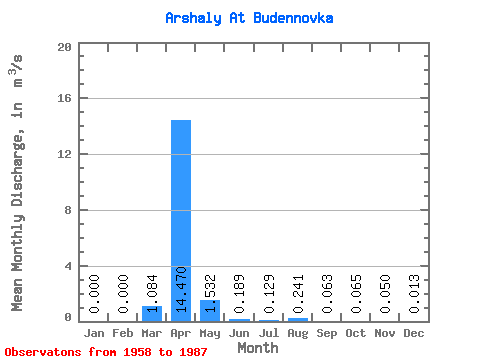
| Statistic | Jan | Feb | Mar | Apr | May | Jun | Jul | Aug | Sep | Oct | Nov | Dec | Annual |
|---|---|---|---|---|---|---|---|---|---|---|---|---|---|
| Mean | 0.00 | 0.00 | 1.08 | 14.47 | 1.53 | 0.19 | 0.13 | 0.24 | 0.06 | 0.07 | 0.05 | 0.01 | 0.77 |
| Standard Deviation | 0.00 | 0.00 | 2.84 | 12.75 | 2.29 | 0.21 | 0.24 | 0.93 | 0.13 | 0.09 | 0.08 | 0.02 | 0.09 |
| Min | 0.00 | 0.00 | 0.00 | 1.44 | 0.06 | 0.00 | 0.00 | 0.00 | 0.00 | 0.00 | 0.00 | 0.00 | 0.70 |
| Max | 0.00 | 0.00 | 9.52 | 60.20 | 11.50 | 0.79 | 1.14 | 4.96 | 0.69 | 0.38 | 0.34 | 0.07 | 0.82 |
| Coefficient of Variation | 2.62 | 0.88 | 1.49 | 1.11 | 1.88 | 3.86 | 2.13 | 1.38 | 1.55 | 1.59 | 0.11 |
 Return to R-Arctic Net Home Page