|
|
|||||||||||||||||
| Point ID: 7062 | Downloads | Plots | Site Data | Code: 11429 |
|
|
|||||||||||||||||
| Download | |
|---|---|
| Site Descriptor Information | Site Time Series Data |
| Link to all available data | |
| View: | Time Series | All |
| Units: | m3/s |
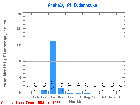
| Statistic | Jan | Feb | Mar | Apr | May | Jun | Jul | Aug | Sep | Oct | Nov | Dec | Annual |
|---|---|---|---|---|---|---|---|---|---|---|---|---|---|
| Mean | 0.00 | 0.00 | 1.01 | 13.02 | 1.42 | 0.17 | 0.12 | 0.22 | 0.06 | 0.06 | 0.04 | 0.01 | 8.38 |
| Standard Deviation | 0.00 | 0.00 | 2.64 | 11.47 | 2.13 | 0.19 | 0.23 | 0.87 | 0.12 | 0.08 | 0.07 | 0.02 | 0.94 |
| Min | 0.00 | 0.00 | 0.00 | 1.30 | 0.05 | 0.00 | 0.00 | 0.00 | 0.00 | 0.00 | 0.00 | 0.00 | 7.71 |
| Max | 0.00 | 0.00 | 8.85 | 54.18 | 10.69 | 0.71 | 1.06 | 4.61 | 0.62 | 0.35 | 0.31 | 0.07 | 9.04 |
| Coefficient of Variation | 2.62 | 0.88 | 1.49 | 1.11 | 1.88 | 3.86 | 2.13 | 1.38 | 1.55 | 1.59 | 0.11 |
 Return to R-Arctic Net Home Page