|
|
|||||||||||||||||
| Point ID: 706 | Downloads | Plots | Site Data | Code: 07DA007 |
|
|
|||||||||||||||||
| Download | |
|---|---|
| Site Descriptor Information | Site Time Series Data |
| Link to all available data | |
| View: | Time Series | All |
| Units: | mm |
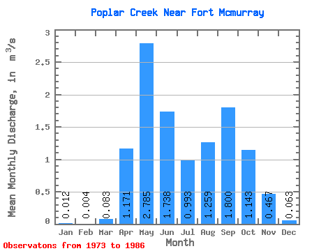
| Statistic | Jan | Feb | Mar | Apr | May | Jun | Jul | Aug | Sep | Oct | Nov | Dec | Annual |
|---|---|---|---|---|---|---|---|---|---|---|---|---|---|
| Mean | 0.01 | 0.00 | 0.08 | 1.17 | 2.79 | 1.74 | 0.99 | 1.26 | 1.80 | 1.14 | 0.47 | 0.06 | 0.96 |
| Standard Deviation | 0.02 | 0.01 | 0.14 | 0.69 | 2.94 | 1.52 | 0.92 | 1.61 | 2.78 | 1.14 | 0.44 | 0.07 | 0.45 |
| Min | 0.00 | 0.00 | 0.00 | 0.30 | 0.23 | 0.09 | 0.11 | 0.08 | 0.03 | 0.15 | 0.04 | 0.01 | 0.35 |
| Max | 0.09 | 0.02 | 0.47 | 2.49 | 9.93 | 5.99 | 3.54 | 5.54 | 9.21 | 4.04 | 1.42 | 0.24 | 1.78 |
| Coefficient of Variation | 2.00 | 1.61 | 1.66 | 0.59 | 1.06 | 0.88 | 0.93 | 1.28 | 1.54 | 1.00 | 0.94 | 1.04 | 0.47 |
 Return to R-Arctic Net Home Page