|
|
|||||||||||||||||
| Point ID: 706 | Downloads | Plots | Site Data | Code: 07DA007 |
|
|
|||||||||||||||||
| Download | |
|---|---|
| Site Descriptor Information | Site Time Series Data |
| Link to all available data | |
| View: | Time Series | All |
| Units: | m3/s |
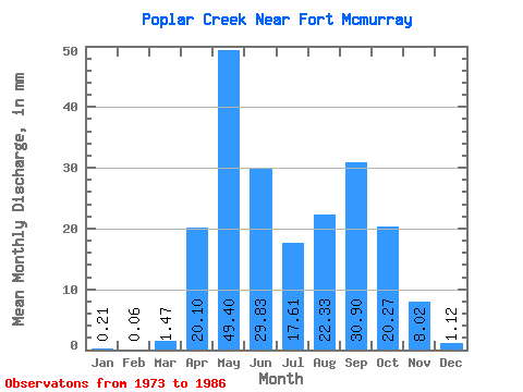
| Statistic | Jan | Feb | Mar | Apr | May | Jun | Jul | Aug | Sep | Oct | Nov | Dec | Annual |
|---|---|---|---|---|---|---|---|---|---|---|---|---|---|
| Mean | 0.20 | 0.07 | 1.48 | 20.09 | 49.39 | 29.83 | 17.60 | 22.32 | 30.89 | 20.27 | 8.02 | 1.12 | 200.59 |
| Standard Deviation | 0.41 | 0.11 | 2.45 | 11.77 | 52.19 | 26.15 | 16.37 | 28.64 | 47.69 | 20.23 | 7.53 | 1.17 | 93.46 |
| Min | 0.00 | 0.00 | 0.00 | 5.15 | 3.99 | 1.46 | 2.02 | 1.42 | 0.45 | 2.64 | 0.70 | 0.11 | 72.51 |
| Max | 1.58 | 0.39 | 8.42 | 42.74 | 176.11 | 102.82 | 62.78 | 98.25 | 158.09 | 71.65 | 24.38 | 4.20 | 372.42 |
| Coefficient of Variation | 2.00 | 1.61 | 1.66 | 0.59 | 1.06 | 0.88 | 0.93 | 1.28 | 1.54 | 1.00 | 0.94 | 1.04 | 0.47 |
 Return to R-Arctic Net Home Page