|
|
|||||||||||||||||
| Point ID: 7056 | Downloads | Plots | Site Data | Other Close Sites | Code: 11411 |
|
|
|||||||||||||||||
| Download | |
|---|---|
| Site Descriptor Information | Site Time Series Data |
| Link to all available data | |
| View: | Time Series | All |
| Units: | mm |
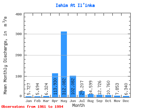
| Statistic | Jan | Feb | Mar | Apr | May | Jun | Jul | Aug | Sep | Oct | Nov | Dec | Annual |
|---|---|---|---|---|---|---|---|---|---|---|---|---|---|
| Mean | 5.73 | 5.69 | 6.32 | 113.93 | 312.08 | 102.08 | 29.21 | 14.60 | 12.73 | 10.76 | 7.85 | 6.34 | 47.80 |
| Standard Deviation | 2.54 | 3.53 | 3.50 | 88.93 | 226.58 | 76.94 | 21.12 | 9.10 | 7.64 | 5.81 | 3.24 | 2.39 | 32.41 |
| Min | 0.59 | 0.29 | 0.34 | 3.46 | 4.54 | 2.12 | 1.07 | 0.74 | 1.14 | 1.10 | 1.18 | 1.19 | 1.78 |
| Max | 10.00 | 16.90 | 16.10 | 287.00 | 723.00 | 262.00 | 84.10 | 34.00 | 31.80 | 22.80 | 14.70 | 12.50 | 113.40 |
| Coefficient of Variation | 0.44 | 0.62 | 0.55 | 0.78 | 0.73 | 0.75 | 0.72 | 0.62 | 0.60 | 0.54 | 0.41 | 0.38 | 0.68 |
| Other Close Sites | ||||||
|---|---|---|---|---|---|---|
| PointID | Latitude | Longitude | Drainage Area | Source | Name | |
| 7141 | "Ishim At Dolmatovo" | 55.30 | -1332617 | SHI | 689.00 | |
 Return to R-Arctic Net Home Page