|
|
|||||||||||||||||
| Point ID: 7056 | Downloads | Plots | Site Data | Other Close Sites | Code: 11411 |
|
|
|||||||||||||||||
| Download | |
|---|---|
| Site Descriptor Information | Site Time Series Data |
| Link to all available data | |
| View: | Time Series | All |
| Units: | m3/s |
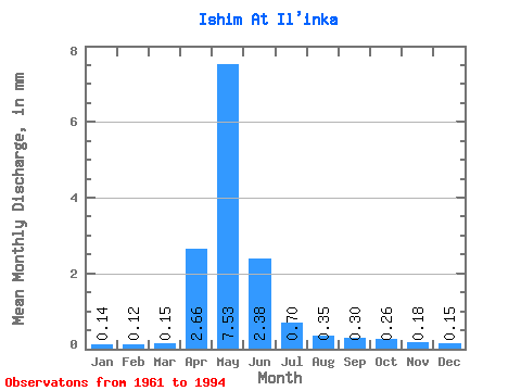
| Statistic | Jan | Feb | Mar | Apr | May | Jun | Jul | Aug | Sep | Oct | Nov | Dec | Annual |
|---|---|---|---|---|---|---|---|---|---|---|---|---|---|
| Mean | 0.12 | 0.11 | 0.13 | 2.27 | 6.43 | 2.04 | 0.60 | 0.30 | 0.25 | 0.22 | 0.16 | 0.13 | 11.60 |
| Standard Deviation | 0.05 | 0.07 | 0.07 | 1.77 | 4.67 | 1.53 | 0.43 | 0.19 | 0.15 | 0.12 | 0.07 | 0.05 | 7.87 |
| Min | 0.01 | 0.01 | 0.01 | 0.07 | 0.09 | 0.04 | 0.02 | 0.01 | 0.02 | 0.02 | 0.02 | 0.03 | 0.43 |
| Max | 0.21 | 0.32 | 0.33 | 5.72 | 14.89 | 5.22 | 1.73 | 0.70 | 0.63 | 0.47 | 0.29 | 0.26 | 27.53 |
| Coefficient of Variation | 0.44 | 0.62 | 0.55 | 0.78 | 0.73 | 0.75 | 0.72 | 0.62 | 0.60 | 0.54 | 0.41 | 0.38 | 0.68 |
| Other Close Sites | ||||||
|---|---|---|---|---|---|---|
| PointID | Latitude | Longitude | Drainage Area | Source | Name | |
| 7141 | "Ishim At Dolmatovo" | 55.30 | -1332617 | SHI | 689.00 | |
 Return to R-Arctic Net Home Page