|
|
|||||||||||||||||
| Point ID: 7053 | Downloads | Plots | Site Data | Other Close Sites | Code: 11407 |
|
|
|||||||||||||||||
| Download | |
|---|---|
| Site Descriptor Information | Site Time Series Data |
| Link to all available data | |
| View: | Time Series | All |
| Units: | mm |
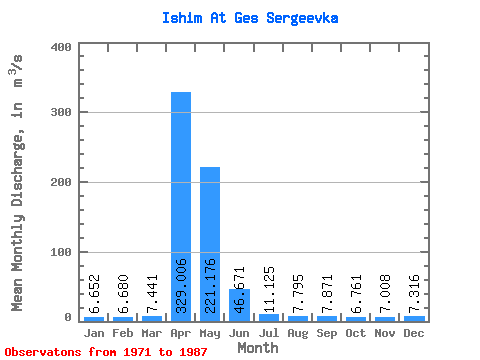
| Statistic | Jan | Feb | Mar | Apr | May | Jun | Jul | Aug | Sep | Oct | Nov | Dec | Annual |
|---|---|---|---|---|---|---|---|---|---|---|---|---|---|
| Mean | 6.65 | 6.68 | 7.44 | 329.01 | 221.18 | 46.67 | 11.12 | 7.79 | 7.87 | 6.76 | 7.01 | 7.32 | 55.46 |
| Standard Deviation | 2.49 | 2.54 | 3.63 | 272.35 | 173.04 | 34.70 | 7.26 | 2.55 | 2.40 | 1.57 | 1.63 | 2.44 | 35.65 |
| Min | 3.74 | 2.40 | 2.85 | 13.80 | 13.20 | 3.43 | 3.22 | 3.17 | 5.26 | 3.77 | 5.20 | 5.10 | 7.57 |
| Max | 13.70 | 13.80 | 15.40 | 820.00 | 684.00 | 118.00 | 30.90 | 15.00 | 15.40 | 10.40 | 12.00 | 15.00 | 114.63 |
| Coefficient of Variation | 0.38 | 0.38 | 0.49 | 0.83 | 0.78 | 0.74 | 0.65 | 0.33 | 0.30 | 0.23 | 0.23 | 0.33 | 0.64 |
| Other Close Sites | ||||||
|---|---|---|---|---|---|---|
| PointID | Latitude | Longitude | Drainage Area | Source | Name | |
 Return to R-Arctic Net Home Page