|
|
|||||||||||||||||
| Point ID: 7053 | Downloads | Plots | Site Data | Other Close Sites | Code: 11407 |
|
|
|||||||||||||||||
| Download | |
|---|---|
| Site Descriptor Information | Site Time Series Data |
| Link to all available data | |
| View: | Time Series | All |
| Units: | m3/s |
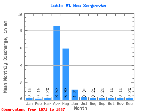
| Statistic | Jan | Feb | Mar | Apr | May | Jun | Jul | Aug | Sep | Oct | Nov | Dec | Annual |
|---|---|---|---|---|---|---|---|---|---|---|---|---|---|
| Mean | 0.16 | 0.15 | 0.18 | 7.82 | 5.43 | 1.11 | 0.27 | 0.19 | 0.19 | 0.17 | 0.17 | 0.18 | 16.06 |
| Standard Deviation | 0.06 | 0.06 | 0.09 | 6.48 | 4.25 | 0.82 | 0.18 | 0.06 | 0.06 | 0.04 | 0.04 | 0.06 | 10.32 |
| Min | 0.09 | 0.05 | 0.07 | 0.33 | 0.32 | 0.08 | 0.08 | 0.08 | 0.12 | 0.09 | 0.12 | 0.12 | 2.19 |
| Max | 0.34 | 0.31 | 0.38 | 19.50 | 16.80 | 2.81 | 0.76 | 0.37 | 0.37 | 0.26 | 0.28 | 0.37 | 33.19 |
| Coefficient of Variation | 0.38 | 0.38 | 0.49 | 0.83 | 0.78 | 0.74 | 0.65 | 0.33 | 0.30 | 0.23 | 0.23 | 0.33 | 0.64 |
| Other Close Sites | ||||||
|---|---|---|---|---|---|---|
| PointID | Latitude | Longitude | Drainage Area | Source | Name | |
 Return to R-Arctic Net Home Page