|
|
|||||||||||||||||
| Point ID: 7052 | Downloads | Plots | Site Data | Code: 11405 |
|
|
|||||||||||||||||
| Download | |
|---|---|
| Site Descriptor Information | Site Time Series Data |
| Link to all available data | |
| View: | Time Series | All |
| Units: | mm |
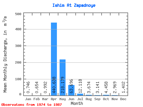
| Statistic | Jan | Feb | Mar | Apr | May | Jun | Jul | Aug | Sep | Oct | Nov | Dec | Annual |
|---|---|---|---|---|---|---|---|---|---|---|---|---|---|
| Mean | 0.75 | 0.65 | 0.99 | 440.64 | 218.18 | 63.70 | 12.12 | 3.67 | 3.14 | 4.46 | 2.97 | 1.40 | 59.70 |
| Standard Deviation | 0.41 | 0.37 | 0.88 | 459.92 | 188.68 | 52.60 | 10.02 | 2.57 | 2.77 | 3.34 | 1.83 | 0.64 | 59.83 |
| Min | 0.27 | 0.23 | 0.18 | 34.20 | 10.80 | 1.77 | 1.04 | 0.64 | 0.46 | 0.87 | 1.15 | 0.62 | 5.13 |
| Max | 1.55 | 1.28 | 2.71 | 1080.00 | 563.00 | 153.00 | 31.10 | 9.24 | 10.90 | 11.30 | 6.80 | 2.69 | 134.39 |
| Coefficient of Variation | 0.56 | 0.57 | 0.88 | 1.04 | 0.86 | 0.83 | 0.83 | 0.70 | 0.88 | 0.75 | 0.62 | 0.46 | 1.00 |
 Return to R-Arctic Net Home Page