|
|
|||||||||||||||||
| Point ID: 7052 | Downloads | Plots | Site Data | Code: 11405 |
|
|
|||||||||||||||||
| Download | |
|---|---|
| Site Descriptor Information | Site Time Series Data |
| Link to all available data | |
| View: | Time Series | All |
| Units: | m3/s |
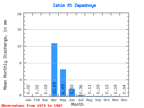
| Statistic | Jan | Feb | Mar | Apr | May | Jun | Jul | Aug | Sep | Oct | Nov | Dec | Annual |
|---|---|---|---|---|---|---|---|---|---|---|---|---|---|
| Mean | 0.02 | 0.02 | 0.03 | 12.69 | 6.49 | 1.83 | 0.36 | 0.11 | 0.09 | 0.13 | 0.09 | 0.04 | 20.93 |
| Standard Deviation | 0.01 | 0.01 | 0.03 | 13.25 | 5.61 | 1.52 | 0.30 | 0.08 | 0.08 | 0.10 | 0.05 | 0.02 | 20.98 |
| Min | 0.01 | 0.01 | 0.01 | 0.98 | 0.32 | 0.05 | 0.03 | 0.02 | 0.01 | 0.03 | 0.03 | 0.02 | 1.80 |
| Max | 0.05 | 0.04 | 0.08 | 31.10 | 16.75 | 4.41 | 0.93 | 0.28 | 0.31 | 0.34 | 0.20 | 0.08 | 47.13 |
| Coefficient of Variation | 0.56 | 0.57 | 0.88 | 1.04 | 0.86 | 0.83 | 0.83 | 0.70 | 0.88 | 0.75 | 0.62 | 0.46 | 1.00 |
 Return to R-Arctic Net Home Page