|
|
|||||||||||||||||
| Point ID: 7051 | Downloads | Plots | Site Data | Code: 11404 |
|
|
|||||||||||||||||
| Download | |
|---|---|
| Site Descriptor Information | Site Time Series Data |
| Link to all available data | |
| View: | Time Series | All |
| Units: | mm |
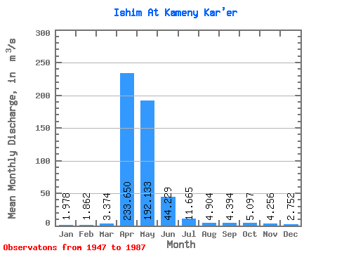
| Statistic | Jan | Feb | Mar | Apr | May | Jun | Jul | Aug | Sep | Oct | Nov | Dec | Annual |
|---|---|---|---|---|---|---|---|---|---|---|---|---|---|
| Mean | 1.98 | 1.86 | 3.37 | 233.65 | 192.13 | 44.23 | 11.66 | 4.90 | 4.39 | 5.10 | 4.26 | 2.75 | 44.48 |
| Standard Deviation | 1.59 | 1.54 | 4.72 | 237.58 | 237.30 | 36.32 | 11.67 | 3.72 | 3.73 | 4.21 | 3.37 | 2.09 | 40.21 |
| Min | 0.07 | 0.21 | 0.10 | 10.30 | 8.54 | 1.80 | 0.99 | 0.47 | 0.47 | 0.36 | 0.32 | 0.17 | 3.93 |
| Max | 7.03 | 7.88 | 20.30 | 955.00 | 967.00 | 125.00 | 63.20 | 15.80 | 19.10 | 21.30 | 13.50 | 8.54 | 175.99 |
| Coefficient of Variation | 0.81 | 0.83 | 1.40 | 1.02 | 1.23 | 0.82 | 1.00 | 0.76 | 0.85 | 0.83 | 0.79 | 0.76 | 0.90 |
 Return to R-Arctic Net Home Page