|
|
|||||||||||||||||
| Point ID: 7051 | Downloads | Plots | Site Data | Code: 11404 |
|
|
|||||||||||||||||
| Download | |
|---|---|
| Site Descriptor Information | Site Time Series Data |
| Link to all available data | |
| View: | Time Series | All |
| Units: | m3/s |
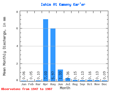
| Statistic | Jan | Feb | Mar | Apr | May | Jun | Jul | Aug | Sep | Oct | Nov | Dec | Annual |
|---|---|---|---|---|---|---|---|---|---|---|---|---|---|
| Mean | 0.06 | 0.05 | 0.10 | 7.03 | 5.97 | 1.33 | 0.36 | 0.15 | 0.13 | 0.16 | 0.13 | 0.09 | 16.29 |
| Standard Deviation | 0.05 | 0.04 | 0.15 | 7.14 | 7.37 | 1.09 | 0.36 | 0.12 | 0.11 | 0.13 | 0.10 | 0.07 | 14.72 |
| Min | 0.00 | 0.01 | 0.00 | 0.31 | 0.27 | 0.05 | 0.03 | 0.01 | 0.01 | 0.01 | 0.01 | 0.01 | 1.44 |
| Max | 0.22 | 0.22 | 0.63 | 28.72 | 30.04 | 3.76 | 1.96 | 0.49 | 0.57 | 0.66 | 0.41 | 0.27 | 64.43 |
| Coefficient of Variation | 0.81 | 0.83 | 1.40 | 1.02 | 1.23 | 0.82 | 1.00 | 0.76 | 0.85 | 0.83 | 0.79 | 0.76 | 0.90 |
 Return to R-Arctic Net Home Page